EQuIS™ (Environmental Quality Information Systems) is an advanced environmental and geotechnical data management and decision support system. Thousands of organizations use EQuIS to manage large amounts of data pertaining to environmental chemistry, biology, geology, geotechnical, hydrology, limnology, water, air, soil, sediment, noise, radiological, waste, and related compliance monitoring. EQuIS supports the complete environmental data workflow for a variety of project requirements including task management, field data collection, analytical data checking, data verification and validation, reporting, graphics, and visualization.
EQuIS applications are integrated together for different user types connected to the same SQL Server or Azure database. See the EQuIS hardware and software system requirements for more information prior to installation.
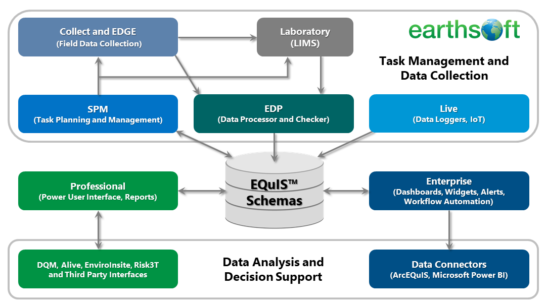
Multiple applications comprise the EQuIS workflow and are most powerful when used together, as illustrated in the figure below.
Brief definitions of various EQuIS applications and modules are provided below.
Core EQuIS Functionality
EQuIS Database – Customizable Schemas for environmental data management. Platform runs on Microsoft SQL Server or Microsoft Azure. Each EQuIS database may have one to thousands of projects.
Professional – Desktop application designed for power-users and data managers. EQuIS Professional is used for data importing and editing, has tools for advanced data analysis and modeling, and provides ultimate power and flexibility.
Enterprise – Web application typically used by managers, auditors, executives, and laboratories. EQuIS Enterprise connects to the same EQuIS database as EQuIS Professional, but provides simple, easy to use tools to view and analyze data and automate workflow. Gain overviews of projects in highly-configurable web dashboards, and download and visualize data instantly and in real-time.
EQuIS Data Processor (EDP) – Desktop or web user interface for checking and importing data into the EQuIS database. Check data for formatting and logic, and find and correct errors easily.
Other EQuIS Applications and Modules
Alive – Designed around ecological surveys, EQuIS Alive includes a separate Schema that is added to an EQuIS database and enables the collection and reporting of ecological data within the other EQuIS applications.
AQS Module – The Air Quality System (AQS) is supported by the United States Environmental Protection Agency (EPA) and contains ambient air pollution data and related meteorological data collected by EPA, state, local, and tribal air pollution control agencies from over thousands of monitors. The EQuIS AQS Module allows clients to collect, store, and manage AQS data in EQuIS and export the data into EPA-required file formats. The EQuIS AQS module can be used with other EQuIS applications, such as the SPM, EDGE, and Collect.
ArcEQuIS – ArcEQuIS is an add-in for Esri ArcGIS Pro to easily view and analyze EQuIS data by directly connecting to an EQuIS Enterprise site.
Collect – A mobile field application for collecting any type of data on a phone, tablet, or laptop. Custom forms to capture data can be created, published, and made immediately available to selected user groups in the field. Manage field data workflow using Collect Enterprise dashboards. Collect, verify, and enforce data quality in real-time.
Data Qualification Module (DQM) – An EQuIS Professional module for assisting environmental professionals with data validation tasks. Review data quality based on defined criteria, setup and customize data checks and rules, and review previous history with DQM.
EQuIS Data Gathering Engine (EDGE) – Application installed on laptops or tablets for field data collection (samples, measurements and inspections) using configured forms. Import EDDs from SPM for planned events. Field data is checked as it is collected and may be submitted immediately to the EQuIS database.
EQuIS EnviroInsite – Desktop application that provides a toolkit for analysis and visualization of environmental data available with EQuIS. Create two-dimensional (2D) and three-dimensional (3D) plots, generate boring logs, evaluate geochemistry, and more.
Geotechnical Module – Add geotechnical data to EQuIS in a consistent format. Includes a separate Schema, format file, various reports and templates, and EQuIS Link, which can be used to easily migrate existing geotechnical data sources (e.g., gINT and AGS) with different data structures to EQuIS.
Link – An advanced tool in Professional EDP for migrating legacy or historical data into EQuIS from a wide variety of input source files to standard EQuIS EDDs.
Live – EQuIS Live enables management of high-frequency, high-volume logger data in EQuIS Enterprise. EQuIS Live includes a separate Schema that is added to an EQuIS database and enables the collection and reporting of data coming from data loggers within the other EQuIS applications.
Power BI Data Connector – The EQuIS Data Connector allows users to access EQuIS facilities, locations, and user reports as data sources directly in Microsoft Power BI.
REST API – EQuIS is interoperable with other software with our REST API, which is used to receive or send information from an EQuIS Enterprise URL (that has a REST API License applied) to perform specific tasks. The EQuIS REST API includes an implementation of OData (Open Data Protocol) that allows users to interact directly with tables, columns, and records in the EQuIS Schema. EQuIS users assigned the REST API role can also connect to an EQuIS Enterprise site with Microsoft Power BI and ArcEQuIS.
Risk3T – Risk3T for EQuIS is an action level calculator. Risk3T evaluates default or site‐specific Risk‐Based Corrective Action (RBCA) levels for environmentally impacted sites, and generates site-specific multiple risk scenarios and corrective action goals. These risk levels can be loaded into EQuIS Action Level tables.
Sample Planning Module (SPM) – Desktop and web user interfaces for planning, scheduling and tracking field sampling events. Generate field Electronic Data Deliverable (EDD) templates, view and download calendars, and monitor the completeness of tasks within SPM.
Third Party Interfaces – Methods for generating output that may be displayed in non-EQuIS ("third party") applications, such as ArcGIS, AutoCAD and many more. Some interfaces connect EQuIS directly to the third party applications. Other interfaces generate output files within EQuIS Professional that may be opened in their respective applications.
Vapor Intrusion Module – Collect, store, manage, and report data associated with vapor intrusion (VI) assessment and monitoring.