Data Sources for Specific Boring Log Elements: |
•Downhole Interval: Geotechnical Sample Elements •Downhole / Point Data: Geotechnical Test and Result Elements |
Parameter Configurations for Boring Log Data:
•Visibility Settings in DT_FACILITY_PARAMETER, DT_TASK_PARAMETER
•Termination Text Settings in DT_LOCATION_PARAMETER
For additional options, see Downhole Intervals or Downhole Point Data.
The Data Sources sections of this article describe the tables and fields of the EQuIS Database that EnviroInsite uses to generate boring logs. The fields listed include those accessed by EnviroInsite to display data directly, as well as fields used to query data for display or to generate calculated values. Italicized fields are available if the Geotech Schema is applied.
For information on configuring the boring log elements (headers (Page, Data, and Title Block), footer, and downhole (chart/log) section), see the Boring Log Template Design Window.
Data Sources for Boring Log Header or Footer Elements
This section describes tables and fields that may be accessed to generate elements contained in the boring log header or footer.
Note that data from DT_DRILL_ACTIVITY may be filtered if a DT_TASK.TASK_CODE is selected when creating a Boring Log. When a TASK_CODE is selected along with locations in the Select Borings window, header data will be filtered by the chosen TASK_CODE. Only DT_DRILL_ACTIVITY records with this TASK_CODE will be plotted on the boring log. For more details, see Header Elements > DT_WATER_TABLE and DT_DRILL_ACTIVITY.
Table |
Field |
|---|---|
DT_FACILITY |
FACILITY_ID |
DT_COORDINATE |
X_COORD Y_COORD |
DT_LOCATION |
LOC_NAME LOC_TYPE LOC_PURPOSE CUSTOM_FIELD_1 CUSTOM_FIELD_2 CUSTOM_FIELD_3 CUSTOM_FIELD_4 CUSTOM_FIELD_5 REMARK_1 BORE_ID REMARK_2 START_DATE END_DATE DRILLING_METHOD GEOLOGIST DRILLER DRILLING_SUBCONTRACTOR DEPTH_TO_BEDROCK BEARING PLUNGE ENGINEER INSPECTOR HOLE_DIAMETER HOLE_DIAMETER_UNIT |
DT_WELL |
WELL_ID INSTALLATION_DATE GEOLOGIST_NAME DRILLER DRILLING_METHOD WELL_OWNER TOP_CASING_ELEV HISTORICAL_REFERENCE_ELEV DEPTH_OF_WELL PUMP_TYPE REMARK DEPTH_TO_BEDROCK CONSTRUCT_CONTRACTOR CONSTRUCT_START_DATE CONSTRUCT_COMPLETE_DATE CUSTOM_FIELD_1 CUSTOM_FIELD_2 CUSTOM_FIELD_3 CUSTOM_FIELD_4 CUSTOM_FIELD_5 |
DT_WATER_TABLE |
SYS_LOC_CODE1 STRIKE_DATE READING#_SEQUENCE** **Number of available readings is the maximum number of up to five (5) readings for a single location for the entire facility. |
DT_DRILL_ACTIVITY |
SYS_LOC_CODE1 DRILL_EVENT* END_DEPTH START_DATE END_DATE ABANDON_YN DIAMETER DIAMETER_UNIT REPLACE_YN DRILL_METHOD PURPOSE FLUID VISCOSITY HAMMER_WT HAMMER_FALL CASING_SIZE LIFT_MECHANISM RIG_DESC RIG_MAKE RIG_MODEL FLUID ROD_DESC BIT_DESC HAMMER_DESC AUGER DESC SAMPLER_DESC DRILLING_PRESSURE REMARK CUSTOM_FIELD_1 CUSTOM_FIELD_2 CUSTOM_FIELD_3 CUSTOM_FIELD_4 CUSTOM_FIELD_5 *Fields from a specific drill event can be used in the boring log by first selecting the DRILL_EVENT in the drop-down. For details, see Header Elements > DT_WATER_TABLE and DT_DRILL_ACTIVITY. |
Page No. |
Posts "Page [current page] of [total number of pages]". |
Today's Date |
Post the day the boring log is created. |
Total Depth1 |
First non-null of DT_LOCATION.TOTAL_DEPTH and DT_WELL.DEPTH_OF_WELL |
1EnviroInsite uses these fields in the background for querying data. They are not available for display on the boring logs.
2EnviroInsite uses the values in these fields to output a calculated value.
Italics - Italicized fields are available in the header/footer if the Geotech Schema is applied.
Data Sources for Lithology Elements
Lithology elements are displayed in the downhole section of the full page boring logs. These elements may be plotted using hatch symbology or as simple text values.
Table |
Field |
|---|---|
DT_LITHOLOGY |
SYS_LOC_CODE REMARK_1 REMARK_2 MATERIAL_NAME GEO_UNIT_CODE_1 GEO_UNIT_CODE_2 GEO_UNIT_CODE_3 GEO_UNIT_CODE_4 GEO_UNIT_CODE_5 MOISTURE PERMEABLE COLOR OBSERVATION GRAINSIZE ODOR CUSTOM_FIELD_1 CUSTOM_FIELD_2 CUSTOM_FIELD_3 CUSTOM_FIELD_4 CUSTOM_FIELD_5 |
Data Sources for Sample Interval Elements
Sample interval elements are displayed in the downhole section of the full page boring logs. These elements may be plotted as fill or other types to indicate the sample depth range or simple text values representative of values in DT_SAMPLE_PARAMETER.
Table |
Field |
|---|---|
DT_SAMPLE |
SYS_LOC_CODE TOP_DEPTH BOTTOM_DEPTH |
DT_SAMPLE_PARAMETER |
SYS_SAMPLE_CODE PARAM_CODE PARAM_VALUE PARAM_UNIT |
DT_DRILL_PARAMETER |
SYS_LOC_CODE PARAM_CODE PARAM_VALUE PARAM_UNIT START_DEPTH END_DEPTH |
Data Sources for Downhole Point Data Elements
Downhole point data elements are displayed in the downhole section of the full page boring logs. These elements may be plotted as simple text values or in profile charts. For more options, see Downhole Point Data.
Note: The following fields are required to plot DT_DOWNHOLE_POINT_DATA in a boring log: |
Table |
Field |
|---|---|
DT_DOWNHOLE_POINT_DATA |
SYS_LOC_CODE PARAM_VALUE DEPTH |
Data Sources for Well Construction Data Elements
Well construction data elements are displayed in the downhole section of the full page boring logs. These elements may be plotted using scaled drawings or simple schematics. The values are all accessed from DT_WELL_SEGMENT. Records from DT_WELL_SEGMENT may refer to either annular fill material or well hardware. The SEGMENT_TYPE record is used to distinguish between the two, based on selections made with EnviroInsite. For more options, see Well Construction.
Table |
Field |
|---|---|
DT_WELL_SEGMENT |
SYS_LOC_CODE SEGMENT_TYPE START_DEPTH END_DEPTH DEPTH_UNIT MATERIAL_TYPE_CODE |
Data Sources for Downhole Interval: Geotechnical Sample Elements
The geotechnical data sources require that the database is configured with the Geotechnical Module.
Geotechnical sample elements are displayed in the downhole section of the boring log via the Downhole Interval Data section in the Boring Log Template Design window. These elements are either directly mapped to values in the database fields named or they are calculated and plotted as fill/symbol or simple text values based on values in DT_GEO_STANDARD_PENETRATION or DT_GEO_CORING.
Table |
Field |
|---|---|
DT_GEO_STANDARD_PENETRATION |
SYS_LOC_CODE START_DEPTH END_DEPTH DEPTH_UNIT SPT_TYPE MAIN_BLOWS_1 MAIN_BLOWS_2 MAIN_BLOWS_3 MAIN_BLOWS_4 N_VALUE n60 n160 |
DT_GEO_CORING |
SYS_LOC_CODE RECOVERY_LENGTH (calculated) |
Note: When plotting numeric data for Geotechnical elements, values are rounded to the nearest tenth decimal. |
Data Sources for Downhole / Point Data: Geotechnical Test and Result Elements
The geotechnical data sources require that the database is configured with the Geotechnical Module.
Geotechnical test and result elements are displayed in the downhole section of the boring log as defined in the Downhole/Point Data section in the Boring Log Template Design window. These elements may be directly mapped from the database or based on filter logic, and are plotted as either simple text values or profile charts.
The GEO_RESULT_CODEs, defined in RT_GEO_RESULT are user-configured parameter codes that define the type of result being stored. Accordingly for these codes, the Boring Log Template Design window displays the user-defined name, rather than the field name. Certain GEO_RESULT_CODEs are hard coded in the EarthSoft Geotechnical format.
The Sample-Test-Result geotechnical data are stored in three tables, where DT_SAMPLE and DT_GEO_RESULT records are related via DT_GEO_TEST as follows:
•DT_SAMPLE.SAMPLE_ID = DT_GEO_TEST.OBJECT_EUID
•DT_GEO_TEST GEO_TEST_ID=DT_GEO_RESULT.GEO_TEST_ID
Table |
Field |
|---|---|
DT_SAMPLE |
SAMPLE_ID START_DEPTH* *Unless start/end depths are populated in DT_GEO_TEST |
DT_GEO_TEST |
GEO_TEST_ID OBJECT_EUID1 TEST_TYPE2 START_DEPTH3 END_DEPTH 3 DEPTH_UNIT 1The DT_GEO_TEST.OBJECT_EUID may be used as either DT_LOCATION.EUID or DT_SAMPLE.SAMPLE_ID. EnviroInsite will only plot data mapped to DT_SAMPLE.SAMPLE_ID 2Only test_types of Unconf_Compression and UnconsolidateUndrain are plotted. See Downhole Point Data > Test Types for additional information. 3If populated, else start/end depths pull from DT_SAMPLE |
DT_BASIC_RESULT |
SYS_LOC_CODE DEPTH CAS_RN RESULT_VALUE |
DT_GEO_RESULT |
GEO_TEST_ID GEO_RESULT_CODE RESULT_VALUE RESULT_VALUE_TEXT |
Settings in DT_FACILITY_PARAMETER / DT_TASK_PARAMETER
The visibility of Downhole Interval Data and Downhole / Point Data elements may be toggled on/off using the Visible check box on the Boring Log Template Design window > Properties grid. See Downhole Groups and Visibility.
Additionally, the Visibility Parameter of the Properties pane displays data from DT_FACILITY_PARAMETER or DT_TASK_PARAMETER param codes that users may select to assign visibility. Visibility settings in DT_TASK_PARAMETER will take precedence over visibility settings in DT_FACILITY_PARAMETER if the PARAM_CODEs are identical. To add PARAM_CODEs to either of these tables, the PARAM_CODE must first exist in the corresponding reference table:
•DT_FACILITY_PARAMETER.PARAM_CODE must first exist in RT_FACILITY_PARAM_TYPE.
•DT_TASK_PARAMETER must first exist in RT_TASK_PARAM_TYPE.
Note that apart from the field not displaying in the boring log, there is no visual indicator within EnviroInsite that visibility has been overridden by a user-selected facility or task parameter. See Boring Log Template Design Window > Downhole Groups and Visibility Section for additional information.
The Termination Text is overridden or enabled for the entire facility by adding a record to DT_FACILITY_PARAMETER as described below.
Table |
Field Name |
Notes |
|---|---|---|
DT_FACILITY_PARAMETER |
PARAM_CODE |
Values must first exist in RT_TASK_PARAM_TYPE with STATUS_FLAG='A''. Downhole Visibility: Prefix with “EI_", followed by text of your choosing. See Boring Log Template Design Window for additional information. Termination Text: Enter “text_at_base_of_log”. |
|
PARAM_VALUE |
Downhole Visibility: Use "N" or "NO" to not display in the downhole section. Termination Text: Enter the column where the text will be added. For example, a PARAM_VALUE = “material_name” will toggle the termination text for the material_name column in an EnviroInsite boring log. |
DT_TASK_PARAMETER |
PARAM_CODE |
Values must first exist in RT_TASK_PARAM_TYPE with STATUS_FLAG='A' Downhole Visibility: RT_TASK_PARAM_TYPE.CONTEXT must equal “EI_Visible_Parameter” to be used for visibility settings. See Boring Log Template Design Window for additional information. |
|
PARAM_VALUE |
Downhole Visibility: Use “N” or “NO” to not display in the downhole section. Use “Y” or “YES” to display in the downhole section. |
Setting Termination Text in DT_LOCATION_PARAMETER
Termination text may be added to the end of a boring log by enabling the Termination Text option in a Downhole Interval Data column options menu. See Downhole Intervals for additional information. Refusal text can be modified by adding a value for each location using:
•DT_LOCATION_PARAMETER.PARAM_CODE = refusal_yn
and
•DT_LOCATION_PARAMETER.PARAM_CODE = refusal_type.
If refusal_yn is set to "Y", the text in refusal_type will display at the end of the log in the format: “{PARAM_VALUE} at {depth} {unit}”. For example: With record PARAM_CODE = refusal type and PARAM_VALUE = "Auger refusal", the display at the end of the boring log is "Auger refusal at 20 feet".
The Termination Text can be overridden/enabled for the entire facility by adding a record to DT_FACILITY_PARAMETER. See Settings in DT_FACILITY_PARAMETER.
Table |
Field Name |
Notes |
|---|---|---|
DT_LOCATION_PARAMETER |
SYS_LOC_CODE |
|
|
PARAM_CODE |
Values must first exist in RT_FACILITY_PARAM_TYPE with STATUS_FLAG='A'. Create two records, one for each: refusal_yn refusal_type |
|
PARAM_VALUE |
refusal_yn Record: Enter "Y" to use the refusal_type text. refusal_type Record: Enter desired text. |
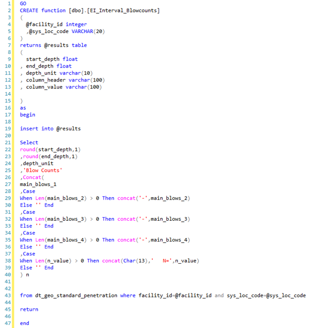
Data Sources for Downhole Function Data
Data from SQL functions may be plotted as boring log columns if configured with the following requirements:
•The function name must begin with "EI_".
•The inputs to the function must be the FACILITY_ID followed by the SYS_LOC_CODE.
•The output of the function must return columns named start_depth, end_depth, depth_unit, column_header, and column_value.
The column_value contains the data to be plotted. If column_header is populated, it will replace the Title Text of the column (if enabled). The start_depth and end_depth columns represent the depth intervals for each column_value. The depth_unit is used for English/metric conversion if applied by the template.
The image below is an example of a compatible custom database function created in SQL Server Management Studio.